


WARRENSBURG – With flash flood and tornado warnings all across the Midwest over the last week, it was advised to stay indoors and off the roads. However, some Johnson County residents took to the streets, with several requiring emergency assistance.
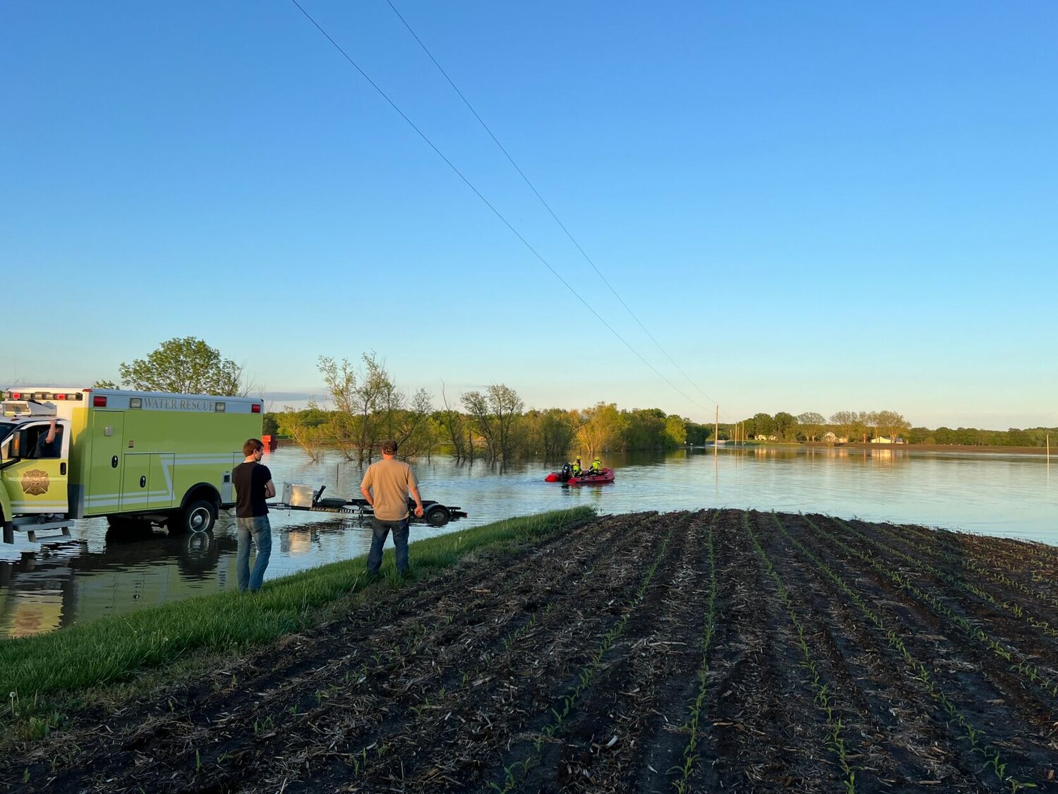
Johnson County Fire Protection District Training and Safety Division Captain Joe Jennings reported three water rescues during the storms that ranged from Thursday, April 25 through Monday, April 29 across the county.
“District personnel have responded to two water rescue incidents today conducting a total of three rescues which required rescuers to enter floodwater,” the district said via a Facebook post Sunday afternoon, April 28.
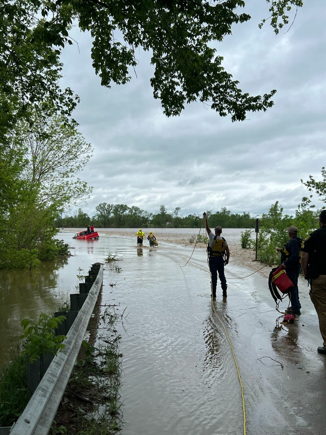
The first two rescues occurred on Sunday, April 28, with the first on West Division Road between Southwest 101 Road and Northwest 151 Road, where two people were rescued from a vehicle submerged in floodwater. The second was on Northeast 151 Road south of the Highway 13 bypass in the Monkey Mountain area, where a vehicle was swept off of a floodwater-covered roadway and sank. The occupant escaped the vehicle, swam in the moving floodwater, and clung to a tree until rescuers retrieved them from the water.
“Our area has had a lot of rain in a short period of time. Areas that typically flood are flooded and areas that don’t normally flood are also flooded,” the district said in the post. “If your path is covered in water, stop, turn around and drive away from it. Do not attempt to drive around warning signs or through any flood water. Turn Around, Don’t Drown!”
“It's one of those things that can be just kind of ignored,” Jennings told the Star-Journal this week. “We kind of think that a little bit of water is not a big deal, but any amount of water on the roadway and covering the roadway can float a car very easily.”
“We don't know what's under that water. So, if you can't see the roadway, there's no sense trying to drive through it. Just turn around and find a different route,” he added.
The National Weather Service out of Kansas City reported the possibility of quarter-sized hail and flash flood warnings for cities in Johnson and Pettis counties for April 27 and 28. It also reported the potential for severe storms in the evening on April 28 that led to the possibility of flash flooding and river flooding in already affected areas with two to five inches of rain.
Needless to say, the roads were treacherous and impassable at times.
“That much rain in a short amount of time, it's going to cause issues in all the normal places as well as the places that we aren't used to flooding,” Jennings said. “Most of the known areas are marked with some sort of signage about being impassable with high water. When it's raining like it has rained in the last week, it's pretty normal for those areas to flood.”
Darrin Tobias, Director of the Johnson County Emergency Management Agency, was driving around the county during the storms, listening to reports from the fire protection district and the NWS on where it was safe to go.
“We live off the radios,” Tobias said. “I'm tracking, jotting down where (the rescues) are and then whenever I can safely go out. Like Sunday, I was out for six hours just driving through the county.”
Tobias drives a large pickup truck and even he knew the dangers of the flood-ridden roads before he left his home.
“When you know that we've had a severe amount of rain and you're driving, even when the rain stops, be aware, slow down and watch what's going on, especially in areas that you know, or suspect that there may be flooding,” Tobias said.
For the county emergency personnel, staying away from the storm was not an option. Upon hearing calls for help, they had to take action, drive out in the rain and find the best solution to save the victims of the floods.
“We've had to have our wonderful firemen and departments going out and doing rescues for people that ended up going into the water instead of turning around,” Tobias said. “It's not only dangerous for the people driving into the water, but it's dangerous for the rescue crews coming in.”
Luckily for commuters in Johnson County, it seems the precipitation will not reach the same volume it did last weekend and should be safer to drive in. The risk of driving in the rain, with roads potentially being washed away or cars experiencing aquaplaning, is still apparent though and drivers should be aware of such risks.
“You really have no idea if you're even, one, driving on the road still or, two, if the road is even still there,” Jennings said. “So it's not just whether you think that you can drive through a little bit of water, you don't know what's under the water or if the road is there.”
“Stay out of the flash flooding,” Tobias said. “Let's keep our responders safe. They'll do their job and they'll come out and help, but if we can, if we can keep them safe too. That would be great.”
The Johnson County EMA is responsible for making its citizens aware of the dangers in the event of floods or other disasters and assessing damage to the county’s buildings, landscape, and citizen vehicles. It works in conjunction with the JCFPD to track and document locations of risk, report on the information, and see if the damage reaches its threshold to request other assistance.
If you have damage related to the floods that occurred last weekend, contact the Johnson County EMA via jocoema.com and fill out a damage assessment form with your contact information and insurance.
Zach Bott can be reached at 660-747-8123.


